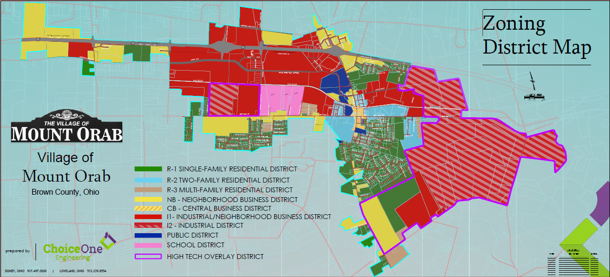
The Village of Mt. Orab is a zoned village. Zoning permits are required for building, improving and altering property located inside the village limits. Zoning permits are handled by the Mt. Orab Zoning Administrator located at 211 South High Street . Permits range in price depending upon the type and size of the project.
Residential Zoning
A zoning permit must be obtained prior to applying for a building permit from the Brown County Building Department for "Residential" projects. . Zoning permits are valid for up to six (6) months from the date issued.
Residential building permits are issued by the Brown County Building Department located at 204 E. Cherry Street in Georgetown, Ohio. The Building Department can be contacted by phone at (937)-378-4716. Building permits are required for all new construction, renovations, installations, and additions to manufactured homes, electrical work, plumbing and sewer changes. Inspections for construction and remodeling are conducted by the Brown County Building Department, while plumbing inspections are conducted by the Health Department.
http://www.browncountyohio.gov/index.php/building-department

https://www.oups.org/homeowners/
Commercial Zoning
A zoning permit must be obtained prior to applying for a building permit from Permit Central for "Commercial" projects. . Zoning permits are valid for up to six (6) months from the date issued.
Commercial building permits are issued by Permit Central located at 2275 Bauer Road in Batavia, Ohio. Permit Central can be contacted by phone at (513) -732-7213. https://permit.clermontcountyohio.gov/
Contact Information
Missy Schneider
Zoning Administrator
211 South High Street
Mt. Orab, OH 45154
(937)-444-6401 Ext. 228
This email address is being protected from spambots. You need JavaScript enabled to view it.
Village of Mt. Orab Zoning FAQ's
Is there zoning in Mt. Orab?
Yes, every parcel of land inside the Village of Mt. Orab is zoned.
What are the different types of property zoning in Mt. Orab?
Property can be zoned residential, business, or industrial.
When do I need to have a zoning permit?
When building a new structure (ex. house, garage), adding to an existing structure, enclosing an area with a fence, building a deck, installing a pool, widening a driveway, adding a storage shed or building, or installing a sign.
Do I also need a building permit?
A building permit is required when constructing a new residence or commercial building. A zoning permit needs to be granted, then apply for a building permit.
Do you need a zoning permit when remodeling an existing building?
If the size or shape of the building or original structure is not changing, you do not need a zoning permit.
Can the zoning of a property be changed?
To change the zoning of a property, the property owner must file a request for the change, pay the application fee, followed by a hearing by the Zoning Board. The Zoning Board has the authority to approve or deny any requested changes. Based on recommendation by the Zoning Board, Village Council would have final approval for any change.
How can I obtain a zoning permit application?
Both residential and commercial applications are available on zoning page or at the Village offices at 211 South High Street.
Is a zoning permit required for a driveway tile?
Yes, and it cannot be smaller than 12" in diameter. If it is plastic it must be double wall with the inside smooth and has to be inspected by the zoning department.
Is a permit needed to fill in a ditch with pipe between the ditch and the street?
Yes, it cannot be smaller thatn 12" in diameter and has to be double wall If it is plastic and it has to be inspected by the zoning department.
2022 Zoning Permit / Application Fees
| RESIDENTIAL |
|
| Single Family Home |
$200.00 |
| Residential Fence |
$40.00 |
| Decks / Porches / Patios |
$40.00 |
| Detached Garage / Acc. Structure |
$50.00 |
| Driveway Additions & Culverts |
$30.00 |
| Addition to House |
$50.00 |
| Addition to Accessory Structure |
$25.00 |
| Storage Building up to 120 sq ft |
$30.00 |
| Storage Building over 120 sq f |
$50.00 |
| POOLS |
|
| Inground Swimming Pool |
$50.00 |
| Above Ground Swimming Pool |
$40.00 |
| |
|
| |
|
| MULTI-FAMILY |
|
| Duplex Two Family Home |
$350.00 |
| Three Family Apartment |
$500.00 |
| Apartment Building |
$175.00 per unit |
| |
|
| INDUSTRIAL / BUSINESS |
|
| General Business |
$200.00 up to 3,000 sf $50.00 for each 1000 sq ft over |
| Industrial Building |
$500.00 up to 5,000 sf $50.00 for each 1000 sq ft over |
| Commercial Fence |
$60.00 |
| Signs / Signage |
$35.00 up to $1000.00 $10.00 per $1000.00 over |
| |
|
| Dog Run |
$25.00 |
| |
|
| Communication Tower |
$250.00 |
| Telecommunications |
$250.00 |
| |
|
| Application for zoning appeal |
$100.00 |
| Application for zoning variance |
$100.00 |
| Application for conditional useage |
$250.00 |
| Application for zoning change |
$300.00 |
| |
|


